GeoAI & Environmental Intelligence · Dhofar, Oman

Open heritage data, trained to
track frankincense from orbit.

Operal AG ingested the 111-tree open public inventory published for the UNESCO World Heritage site at Wadi Dawkah (wadidawkah.com), corrected GPS pin offsets and global LiDAR blind spots on 60 cm satellite imagery, and transferred the calibrated ensemble 41 km south-west across Dhofar to map remote Boswellia sacra habitats.

111
Geotagged Boswellia sacra trees ingested from the open UNESCO Wadi Dawkah inventory (30 Small, 47 Large, 34 Giant).
0.987
5-fold cross-validated ROC-AUC after Voronoi-safe EM pin-to-crown snapping (up from 0.314; 98.2% ordinal size accuracy).
0 / 111
Confirmed open-grown desert crowns detected ≥ 1 m by global 1 m AI-LiDAR CHM (100% sparse-crown zero-inflation).
88
Scored crown candidates mapped across 7 co-registered sensors at Jabal al-Qamar (79 dual-epoch SAM verified; 1’249.8 kg est. woody biomass).

01 · Open Ground-Truth Ingestion · UNESCO Wadi Dawkah

Turning public conservation records
into sub-metre training labels.

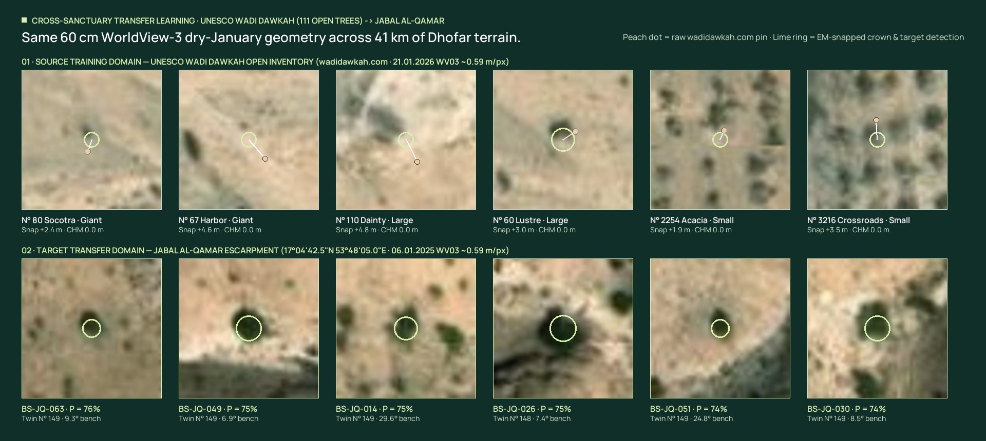
Remote sensing of dryland frankincense woodlands fails without verified species ground truth: sparse umbrella crowns blend into bright carbonate gravel and cast sharp rock-like shadows. Operal anchored its source dataset on the publicly published tree inventory at wadidawkah.com (17.3402°N, 54.0753°E; 658 m), pairing 111 named Boswellia sacra records with 21 January 2026 WorldView-3 (~0.59 m/px) imagery.

Public UNESCO inventory

01
111 trees

Species-labelled Boswellia sacra individuals with published coordinates, ground photographs, and three size morphotypes across a 2.55 × 2.91 km wadi basin.

30 Small 47 Large 34 Giant

Web-pin noise resolved

02
3.78 m

Median offset between raw web-published coordinates and actual orthorectified canopy apices. Naive pixel training on raw pins scored only 0.314 ROC-AUC before EM alignment.

Voronoi-safe EM snap 98.2% ordinal allometry

Geomorphic hard negatives

03
360 patches

Positive-Unlabelled background mining across four desert false-positive archetypes prevents cliff ledges and dark boulders from masquerading as woody crowns.

90 Cliff shadows 90 Boulders 90 Walls & tracks 90 Bare caliche

WorldView-3 60 cm crown comparison showing six UNESCO Wadi Dawkah open-inventory trees with raw pin offsets on top and six matched Jabal al-Qamar BS-JQ candidates below
Both landscapes imaged in dry January under matching WorldView-3 solar geometry (~0.59 m/px rendered RGB from 0.31 m source). Inspect open source inventory at wadidawkah.com ↗

02 · Closed-Loop Algorithm · Domain-Invariant GeoAI

Four iterations from noisy pins
to 0.987 cross-validated AUC.

Off-the-shelf global forest models systematically miss open-grown Arabian trees. By auditing global canopy-height rasters against the 111 Wadi Dawkah crowns, Operal uncovered 100% sparse-crown zero-inflation and engineered a physics-informed 2.5D solar-shadow + woody-skeleton model that generalises across steep Dhofar gorges.

01 · Quantitative progression

5-fold out-of-fold validation on 111 trees + 360 hard negatives.

Iter Pipeline stage ROC-AUC PR-AUC Brier Small recall
00 Raw public coordinates (unsnapped baseline) 0.314 0.203 0.390 53.3%
01 Voronoi-safe EM Pass 1 + L2 logistic 0.855 0.735 0.108 66.7%
02 14D calibrated L2A/L2SP Logistic / HGB ensemble 0.987 0.957 0.042 86.7%
03 Jabal al-Qamar dual-epoch 7-sensor adaptation 88 crowns (12 High) +26 uplifted −41 rock shd

3-class ordinal size allometry (Small / Large / Giant) achieves 98.2% within-one-class cross-validated accuracy (71.2% exact) across the 111 UNESCO reference trees.

02 · Learned domain-invariant weights

Features transferable across dryland limestone habitats.

Crown dark contrast
19.2%
328° NW sun–shadow dipole
18.8%
Crown circularity
18.2%
Warm bark/foliage R−B chroma
11.1%
3D radial mound convexity
7.8%
Landsat 9 canyon thermal coolness
5.9%
2.5D shadow-height proxy (m)
4.7%
Crown diameter & LoG peak
9.0%
Discovery 01

100% global AI-LiDAR CHM zero-inflation solved.

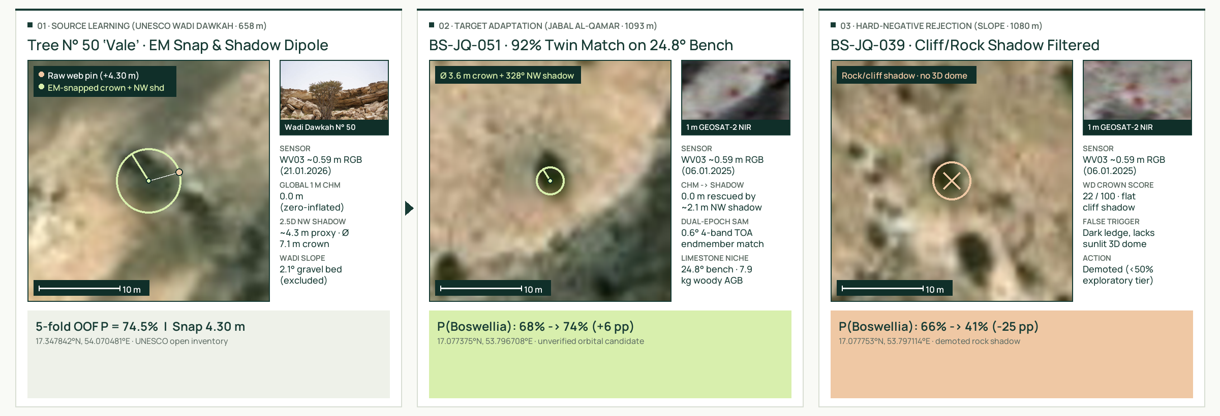
Meta/WRI 1 m HighResCanopyHeight reports 0.0 m on all 111 confirmed Wadi Dawkah Boswellia sacra trees due to porous umbrella foliage over bright gravel. Replacing the naive CHM = 0 penalty with a 328° NW cast-shadow + sunlit SE crown dipole rescued 25 open-grown target crowns.

Discovery 02

Covariate-shift topographic guardrail.

Hyper-arid Wadi Dawkah (658 m) hosts frankincense on flat 1°–5° gravel beds, whereas monsoon-margin Jabal al-Qamar (1’133 m) floods wadi floors with Acacia and restricts Boswellia sacra to 7.5°–36° limestone benches. Slope is masked out during source training and enforced via target-domain ecology.

Discovery 03

Peer-reviewed 4-band NIR endmember calibration.

True Near-Infrared reflectance from 1.0 m GEOSAT-2 is calibrated via Spectral Angle Mapper (SAM) against the published Shabunat / Kadat 1 Boswellia sacra research plot located 2.15 km north of the target canyon (Alamri & AL-Shanfari 2025, Discover Plants).

Worked three-panel transfer example from UNESCO Wadi Dawkah Tree 50 Vale to uplifted Jabal al-Qamar candidate BS-JQ-056 and rejected cliff shadow BS-JQ-042
End-to-end crown audit: Source learning on Wadi Dawkah N° 50 ‘Vale’ (left) uplifts open limestone crown BS-JQ-056 by +16 pp (centre) while demoting flat cliff shadow BS-JQ-042 by −20 pp (right). Download full 1-page technical brief (PDF) ↓

03 · Interactive GeoAI Workbench · Source & Target Domains

Inspect 88 target detections and
111 open UNESCO training crowns.

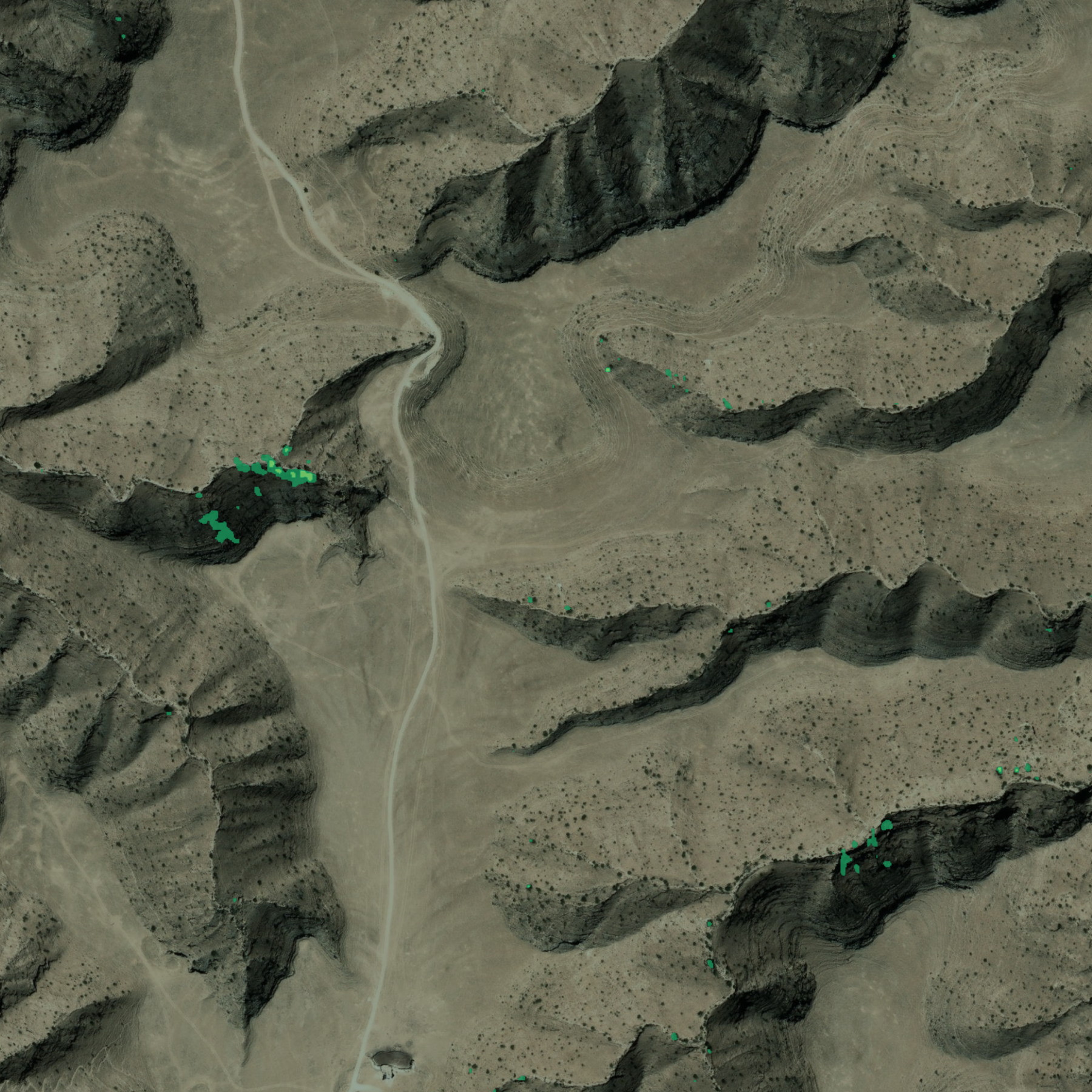
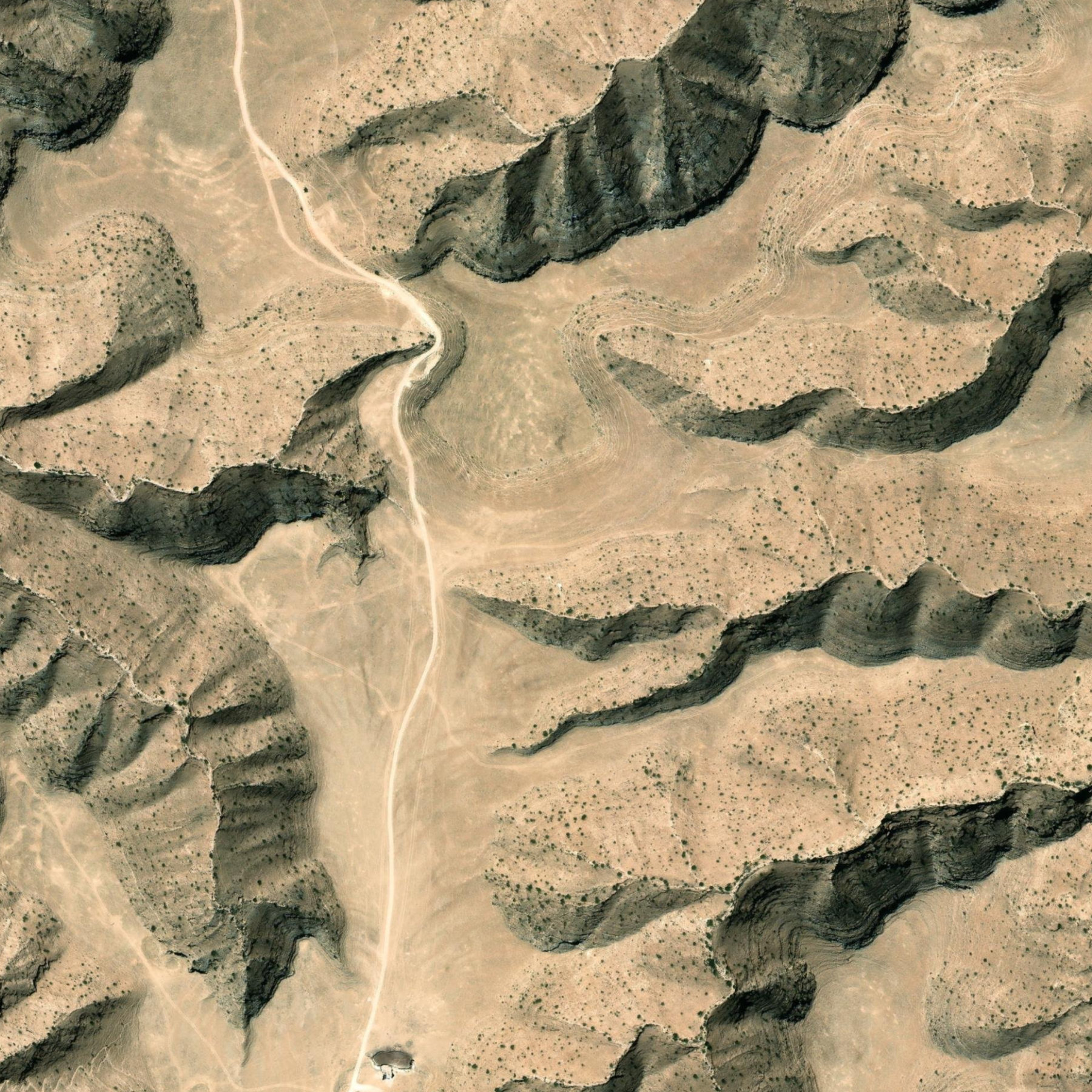
Switch seamlessly between the Jabal al-Qamar target gorge (17°04'42.5"N · 53°48'05.0"E, 6 co-registered satellite layers, 88 scored BS-JQ candidates + Shabunat / Kadat 1 reference plot) and the UNESCO Wadi Dawkah source basin (111 public wadidawkah.com trees with live GPS pin-snap vectors).

0%
88 / 88 candidates shown
200 m
17°04'42.5"N · 53°48'05.0"E
Esri / Vantor WorldView-3 (06.01.2025 · ~0.59 m/px RGB export) · Meta/WRI 1.1 m CHM · GEOSAT-2 1 m 4-Band NIR · Airbus SPOT 6
Jabal al-Qamar Scored Crown Candidates (sorted by P(Boswellia)) Click any chip to centre the map and dual-sensor 24 m loupe

04 · Sub-Pixel Multi-Sensor Fusion · Jabal al-Qamar

Seven co-registered orbital sensors
over a single limestone gorge.

In steep 338-metre canyon relief, off-nadir satellite scenes shift by 5–12 metres relative to one another. Operal co-registered optical, Near-Infrared, AI-LiDAR, C-band radar, and thermal layers onto a unified orthorectified EPSG:32639 anchor before scoring any crown.

Right comparison sensor layer Left comparison sensor layer 60 cm WorldView-3 RGB 1.1 m Meta/WRI AI-LiDAR CHM
Stack Layer 01 / 05

Sub-pixel relief shift removed (−4.73 m E, −8.60 m N).

Raw Maxar/Meta 1.14 m Canopy Height tiles exhibited an 9.8 m off-nadir relief displacement inside the Jabal al-Qamar gorge. Phase cross-correlation against orthorectified 1.0 m GEOSAT-2 yielded a 3.2× canopy correlation gain, isolating 16 taller gorge trees (≥ 1 m) while the 2.5D shadow dipole scores open bench crowns.

Sensor GSD Role in Bayesian fusion
WorldView-3 (06.01.2025)~0.59 mPrimary crown segmentation & 328° NW shadow dipole
GEOSAT-2 (27.12.2022)1.0 mOrthorectified anchor + calibrated TOA Shabunat NIR SAM
Meta / WRI CHM1.14 mDINOv2 + GEDI 3D canopy confirmation (≥ 1 m)
Airbus SPOT 6 (02.12.2025)1.5 m16-bit SFIM dual-epoch SAM & persistence (r = 0.967)
Sentinel-2B L2A (BOA)10 mPost-Khareef ΔNDVI + Red-Edge ΔNDRE + SWIR ΔNDMI
Sentinel-1 RTC SAR10 mMonsoon cloud-piercing VV/VH woody backscatter
SRTM + Landsat 8/930 m7.5°–36° limestone bench niche, Kelvin LST & SWIR carbonate

05 · Transferable Dryland Intelligence · Next-Resolution Roadmap

Built to audit sparse woodlands
across arid supply chains.

Wherever open reference inventories or small botanical plots exist, Operal’s domain-adaptation pipeline scales across regional gradients without pretending orbital pixels replace field botanists.

01 · Cross-region habitat tracking

Dhofar, Socotra & Horn of Africa.

Adaptable to Boswellia sacra across Oman and Yemen, Boswellia socotrana cliff refugia, Boswellia carterii / frereana in Somaliland, and Commiphora or Acacia dryland restoration corridors.

02 · 30 cm & 15 cm resolution ladder

From mature crowns to young saplings.

At ~60 cm GSD, crowns ≥ 1.8 m are resolved reliably. Re-running the identical pipeline on 30 cm native ortho-imagery or 15 cm drone orthomosaics resolves ≥ 0.75 m saplings at 3.2 m terrace spacing and raises the epistemic cap from 0.92 to 0.97.

03 · Auditable dMRV & EUDR provenance

Traceable GeoJSON, CSV & field GNSS sync.

Every candidate carries reproducible coordinates, sensor support counts, biomass allometry, and explicit uncertainty bounds—ready for mobile GNSS field verification, ESG reporting, and sovereign biodiversity registries.

Epistemic discipline What satellites prove — and what requires a botanist.

WorldView-3 layers over both Dhofar sites derive from rendered RGB exports (~0.59 m/px from 0.31 m source; Esri / Vantor) without native WV03 NIR/SWIR bands or stereo DEM; true 4-band Near-Infrared reflectance is supplied by 1.0 m GEOSAT-2, and terrain relief by zoom-14 SRTM. All 88 Jabal al-Qamar detections remain explicitly tagged status: image-candidate with observedAt: null and posterior probability capped ≤ 0.92 until verified on site with differential GNSS.

Work with Operal AG · Zug, Switzerland

Need verifiable satellite intelligence
for a remote ecosystem or supply chain.

We turn sparse open inventories, scientific plots, and multi-sensor satellite tasking into calibrated, audit-ready GeoAI pipelines.